Build From
What’s Actually
There
Stop bidding, planning, and building against drawings that don’t reflect the existing conditions. MeasureBuilt delivers laser-accurate as-built documentation so your team has the right numbers before the first tool hits the site.
Change Orders Start With Bad Data
Most construction change orders trace back to the same source: the drawings that were handed over at the start of a project didn’t accurately reflect what was already built. Walls are in different positions. Dimensions don’t add up. Structural elements aren’t where the records say they are.
For contractors, that means costly field corrections, delayed schedules, and difficult conversations with clients. For property owners, it means renovation budgets that blow out before the first wall comes down. The fix isn’t more contingency — it’s better data at the start.
-
receipt_longChange orders triggered by dimension discrepancies between drawings and field conditions
-
scheduleSchedule delays caused by teams re-measuring on-site what should have been documented before mobilisation
-
warningStructural surprises uncovered during demolition that weren’t captured in existing records
-
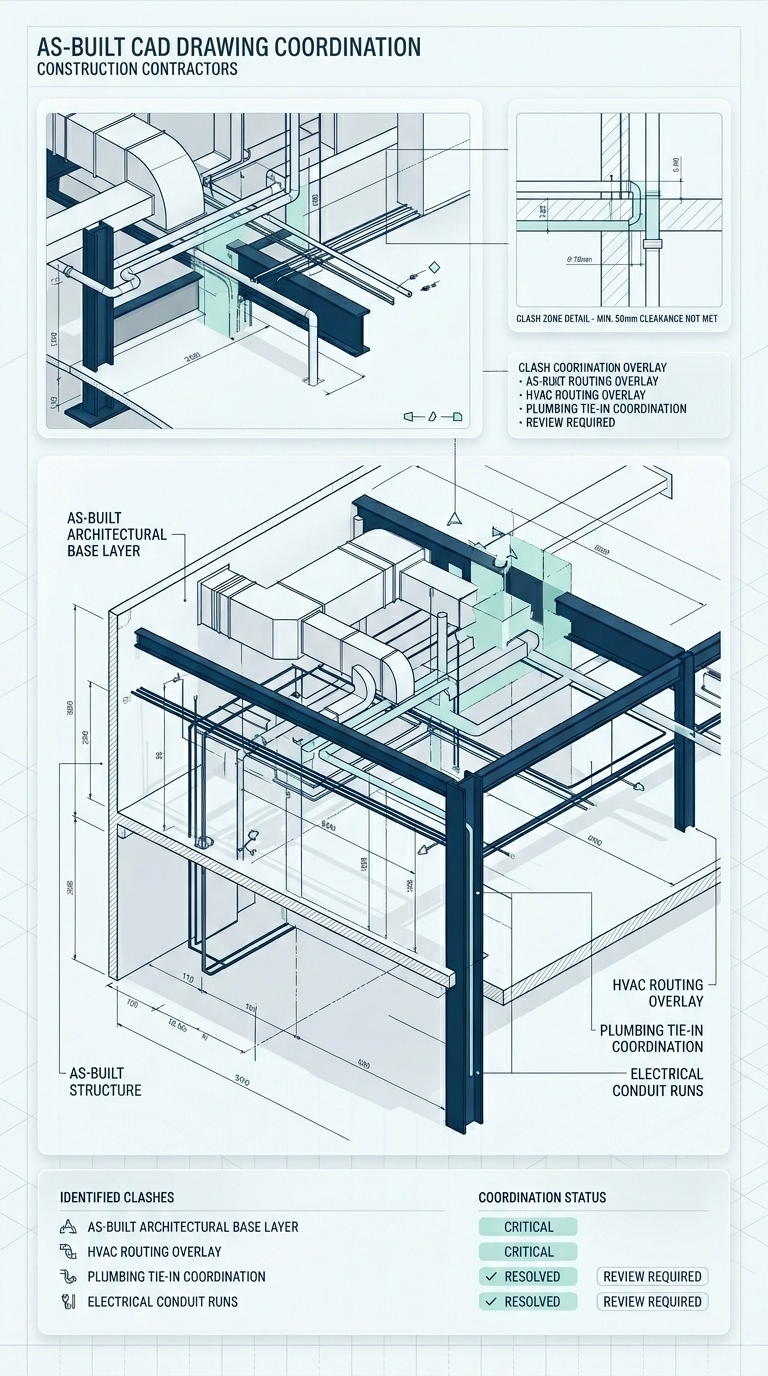
layers_clearNo reliable as-built base for sub-trade coordination — MEP clashes discovered in the field instead of on paper
-
price_changeRenovation budgets based on guessed dimensions — actual quantities only known once work is already underway
Accurate Data
Before You Build
A verified as-built survey before mobilisation is the lowest-cost risk mitigation available on any renovation or fit-out project.
Eliminate Change Orders
When your bid and your build plan are based on laser-accurate existing conditions, the gap between estimate and final invoice shrinks dramatically. No more “we didn’t know the wall was there” conversations.
Coordinate Sub-Trades Upfront
Give your structural, MEP, and fit-out sub-trades a verified as-built model before they mobilise. Clash detection happens on paper — not in the ceiling void at 7am on a Tuesday.
Protect Your Scope
An independent as-built survey at project start creates a documented baseline of existing conditions. If scope changes arise, you have a clear record of what was there before your team touched anything.
Standard Deliverables
AutoCAD (DWG)
Layered, fully dimensioned 2D plans, elevations, and sections — ready for immediate use in estimating, shop drawings, and construction coordination.
Print-Ready PDF
Annotated, scaled drawings with title blocks — ready to include in tender packages, client presentations, and permit applications without additional formatting.
Revit (RVT) Models
Intelligent 3D BIM models with wall types, structural elements, ceiling heights, and MEP routing — the as-built base your coordination team needs before any new design work begins.
Point Cloud Data
Raw 3D scan data in RCP / E57 format — for BIM coordination, structural analysis, and any situation where your team needs to interrogate the geometry directly.
Services Built for Your Projects
From a single residential renovation to a large-scale commercial fit-out — every deliverable is formatted to slot directly into your construction workflow.
Floor Plans
Laser-accurate as-built floor plans with full dimensions, wall thicknesses, and structural element locations — the verified base your estimators and site team need before a project begins.
Elevations
Full exterior and interior elevation drawings capturing true heights, window and door locations, cladding transitions, and roof geometry — essential for facade works, additions, and permit applications.
Reflected Ceiling Plans
Ceiling heights, lighting, HVAC grilles, sprinkler heads, and all overhead elements documented per room — the drawing your ceiling and fit-out sub-trades need before pricing any new ceiling system.
Mechanical Drawings
As-built HVAC, plumbing, and MEP system drawings showing duct routing, pipe runs, and equipment positions — the verified baseline that keeps your sub-trades coordinated and your project on programme.
Site Plans
Accurate site plans documenting building footprint, boundaries, setbacks, and all site features — required for permit applications, council submissions, and any project involving works to the building envelope.
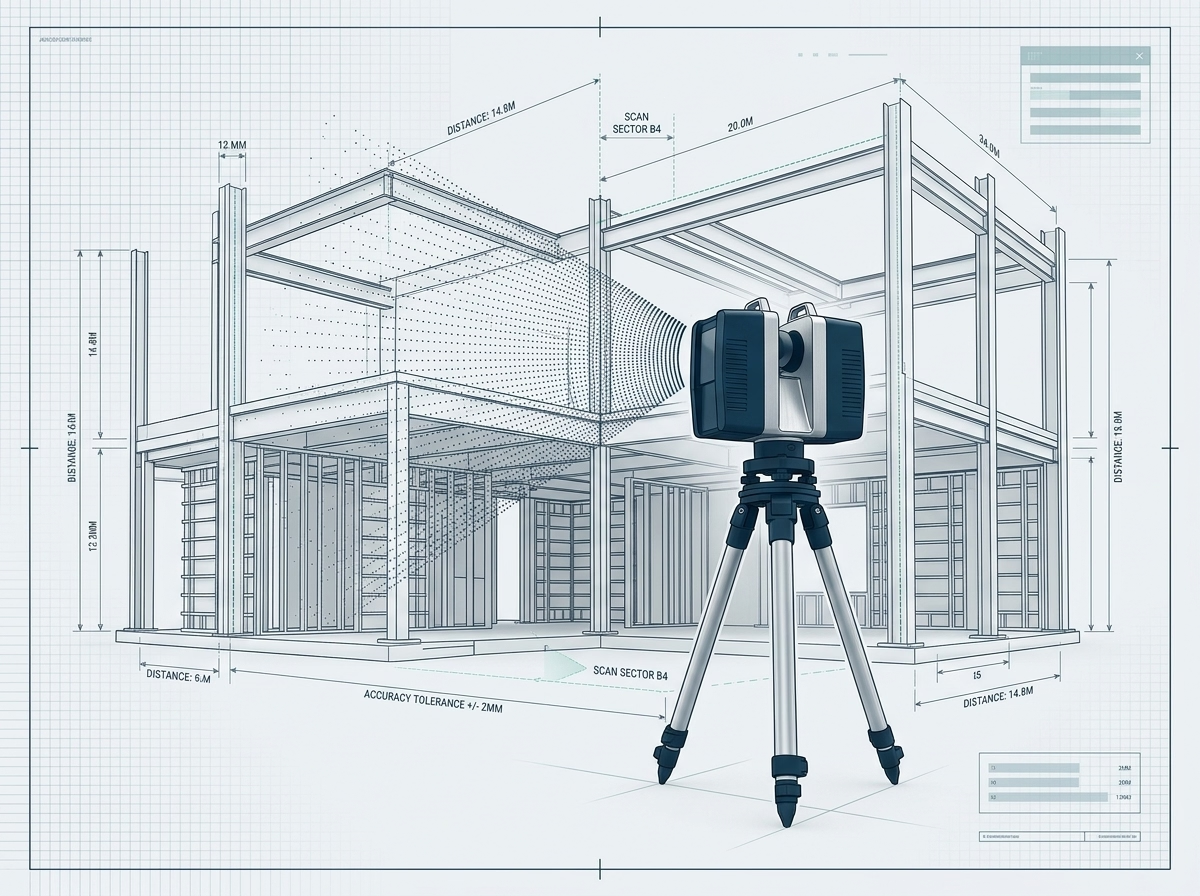
LiDAR Surveying
Full 3D point cloud capture of the existing structure — delivered in RCP, E57, or RCS format so your BIM coordinator or structural engineer can work directly from the scan geometry.
How It
Works
One site visit before mobilisation. Every drawing your project needs. Delivered in 72 hours so your team can start the real work.
Project Scope Review
We review the building type, project scope, required drawing types, and any access constraints — plant rooms, occupied tenancies, or phased site access — before scheduling the capture visit.
On-Site LiDAR Capture
Our technician deploys the GeoSLAM Zeb Revo scanner and captures the complete existing geometry of the building in a single visit — every space, every level, every accessible structural and MEP element.
Drafting, QA & Delivery
Our team produces your full drawing set from the point cloud — floor plans, RCPs, MEP layouts, elevations, or a Revit BIM model — peer-reviewed and delivered within 72 hours, ready for immediate use on site.