Your Creative
Vision Needs
Accurate Data
Stop designing against inaccurate paper plans. MeasureBuilt delivers laser-measured, BIM-ready as-built documentation so you can spend more time designing and less time verifying dimensions in the field.
Outdated Plans Kill
Great Projects
Every architect and interior designer knows the scenario: you spend weeks developing a renovation concept against existing drawings, only to discover on site that walls are in the wrong place, ceiling heights don’t match, or non-standard conditions weren’t recorded at all.
Those discoveries cost you time, credibility, and money — in contractor change orders, redesign hours, and missed deadlines. The root cause is almost always the same: the as-built data your project started from was never accurate to begin with.
-
warningContractor change orders caused by dimension discrepancies in base plans
-
loopRepeated site visits to re-measure what should have been captured once
-
scheduleDesign hours wasted resolving conflicts between drawings and reality
-
edit_offInaccurate ceiling heights and wall thicknesses not reflected in existing records
-
layers_clearNo reliable BIM-ready base model to begin the design development phase
Why Accuracy
Matters
In architectural practice, a 2-inch discrepancy can derail an entire renovation. We provide the structural certainty you need from day one.
Start Designing Faster
Skip tedious manual measuring. Receive complete project files within 72 hours of site capture and move straight into the creative phase — with verified dimensions already in your CAD environment.
Eliminate Costly Revisions
Avoid site-return trips and contractor change orders caused by inaccurate base plans. Our surveys are guaranteed to within ±1/8″ — the standard required for professional architectural work.
Seamless Software Integration
Our outputs are natively formatted for your stack. AutoCAD, Revit, SketchUp, and ArchiCAD — our files work immediately, with no cleanup, layer restructuring, or unit conversion required.
Services Built for Your Practice
Every deliverable we produce is formatted for immediate use in architectural and interior design workflows — no intermediary steps, no manual cleanup.
Floor Plans
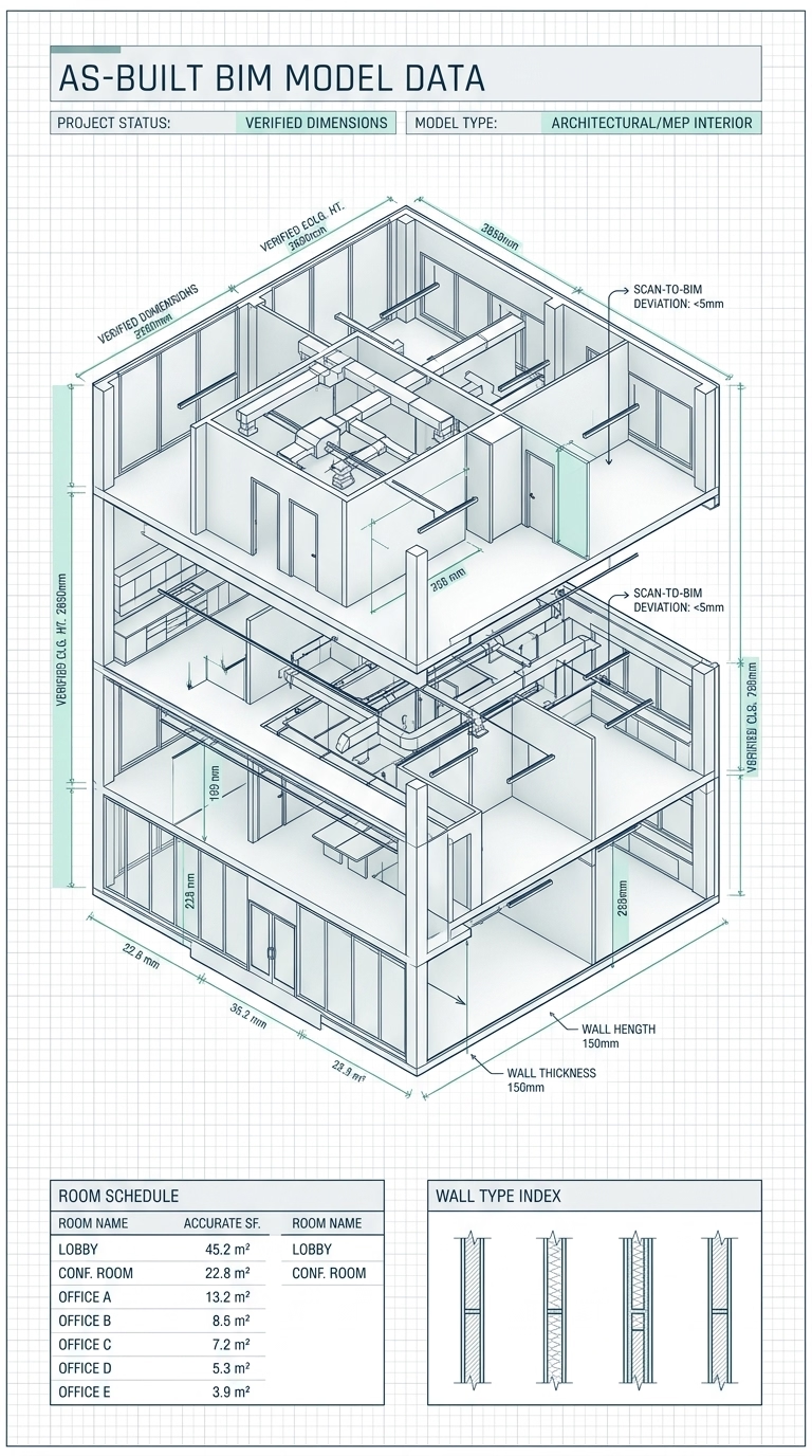
Fully dimensioned as-built floor plans in AutoCAD or Revit — wall thicknesses, door swings, window locations, and all structural elements documented to ±1/8″.
Elevations
Exterior and interior wall elevations showing true heights, fenestration, and material transitions — essential for renovation design and planning submissions.
Reflected Ceiling Plans
Ceiling heights, lighting fixtures, HVAC grilles, and all overhead elements documented per room — the drawing your lighting and FF&E design depends on.
Site Plans
Permit-ready site plans showing building footprint, setbacks, and all site features — required for planning applications and exterior renovation approvals.
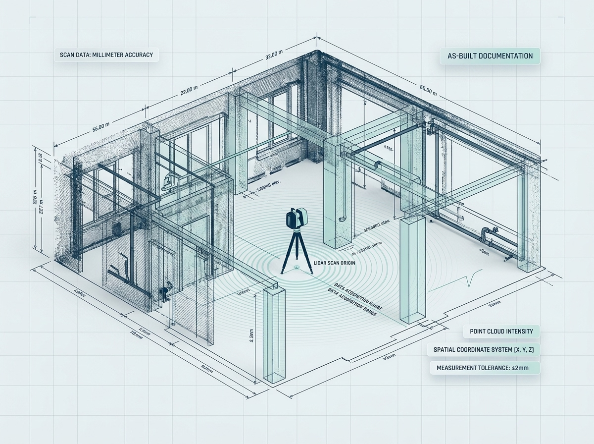
LiDAR Surveying
The raw point cloud data behind every drawing — delivered in RCP or E57 format so your BIM team can work directly with the source geometry in Revit or Navisworks.
Mechanical Drawings
Existing HVAC, plumbing, and MEP system drawings — critical when designing new ceiling systems, wet areas, or any space where services need to be coordinated before construction.
Standard Deliverables
AutoCAD (DWG)
Layered, organised 2D plans, elevations, and sections — ready for immediate drafting in your existing CAD environment.
Print-Ready PDF
High-fidelity vector PDFs with architectural title blocks, dimensions, and annotations — ready for client presentations and planning submissions.
Revit (RVT) Models
Intelligent 3D BIM models with wall types, window schedules, ceiling heights, and structural geometry — the base model your team needs to begin design.
Point Cloud Data
Comprehensive 3D point cloud scans in RCP / E57 format — for BIM coordination, complex structural analysis, and heritage documentation.
Our Proven
Process
We capture the data so you can focus on the creative design. From initial brief to final delivery, precision is built in at every step.
Technical Intake
We review your project scope, required drawing types, LOD requirements, and preferred software formats — so the deliverables slot directly into your workflow.
Rapid On-Site Capture
Our technicians deploy the GeoSLAM Zeb Revo LiDAR scanner and capture the full building geometry in hours — a single visit that produces all the data your project needs.
Drafting & Rigorous QA
Our architectural technicians convert the point cloud into clean, professionally drafted drawings through a three-stage QA process — verified against scan data before anything leaves our office.