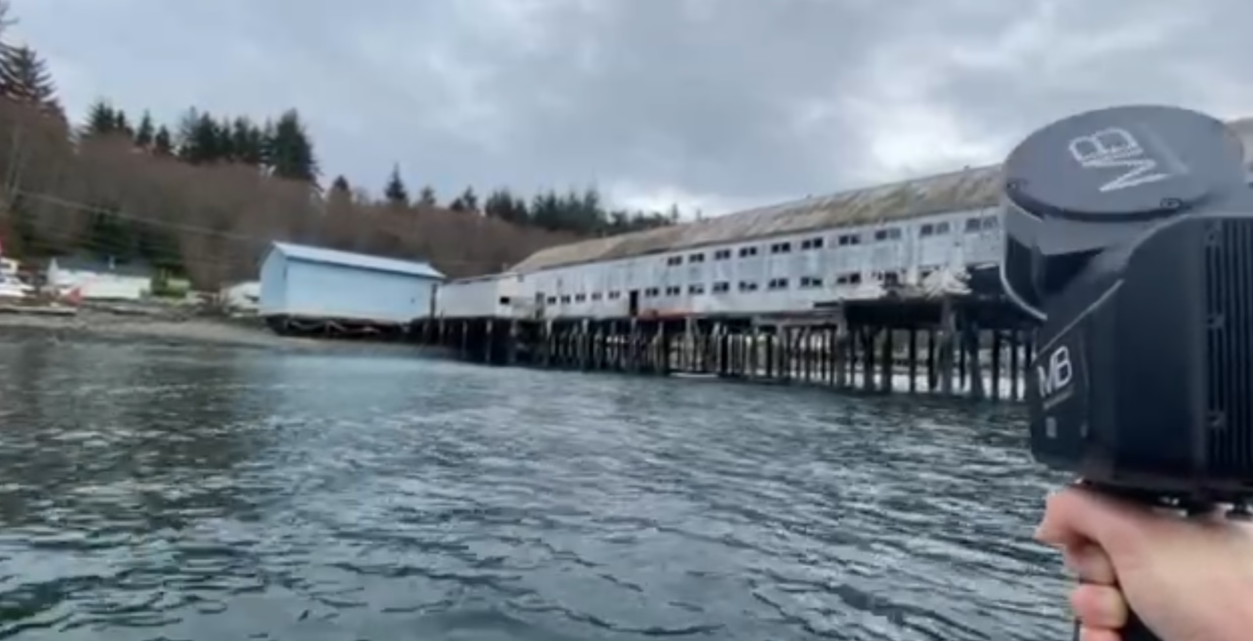
Remote Pier & Net House — Northern BC
Northern British Columbia, Canada
Marine / Pier & Elevated Net House
Laser Scanning to 3D Revit BIM — Full Structural Documentation
Pier & Net House As-Built Documentation in British Columbia
High-accuracy pier laser scanning and marine structure as-built modeling in British Columbia, including remote and hard-to-access locations. We capture complex structures from both land and water, delivering precise 3D BIM models in Autodesk Revit for engineering, renovation, and asset management.
Our workflow is designed for challenging environments where traditional measurement methods are impractical or incomplete.
We provide complete as-built documentation and 3D modeling for:
- Piers and wharfs
- Net houses and elevated marine buildings
- Coastal and waterfront structures
- Timber and steel marine framing systems
- Remote and difficult-access infrastructure
Our deliverables accurately represent existing conditions, including structural systems above and below deck.
Northern British Columbia, Canada
Laser Scanning in Remote & Marine Environments
Marine structures present unique challenges — limited access to critical components, structures extending over water, variable site conditions, complex geometry, and remote locations. To address this, we use handheld laser scanning combined with multi-position capture strategies, approaching the structure from both land and water.
Land-Based Scanning
- check_circle Pier decking and access areas
- check_circle Net house structure and framing
- check_circle Visible structural systems
Boat-Based Scanning
- check_circle Underside of pier decking
- check_circle Structural piles and supports
- check_circle Cross-bracing and submerged-adjacent elements
This hybrid method ensures complete coverage of the structure, including areas that are typically inaccessible.
Case Study — Northern BC
- check_circle Multi-Position Laser Scanning (Pier + Boat-Based)
- check_circle Full Structural Documentation Above & Below Deck
- check_circle Point Cloud Processing & Registration
- check_circle Complete 3D BIM Model Delivered in Revit
Output Formats
From Point Cloud to 3D Revit Model
A structured two-stage process that converts raw marine scan data into accurate, engineer-ready BIM documentation in Autodesk Revit.
Registering a Unified Structural Model
After data capture, all scans from land and water are processed and registered into a single coordinated model. Scan positions from both above and below the pier are aligned into a unified coordinate system, creating a complete digital representation of the structure.
An accuracy verification pass ensures consistency across all structural elements before any BIM modeling begins.
Key Outcomes
- check_circle Land and boat scans registered into one model
- check_circle Accuracy verification across all structural elements
- check_circle Clean, optimized dataset ready for Revit modeling
Detailed BIM Model of the Marine Structure
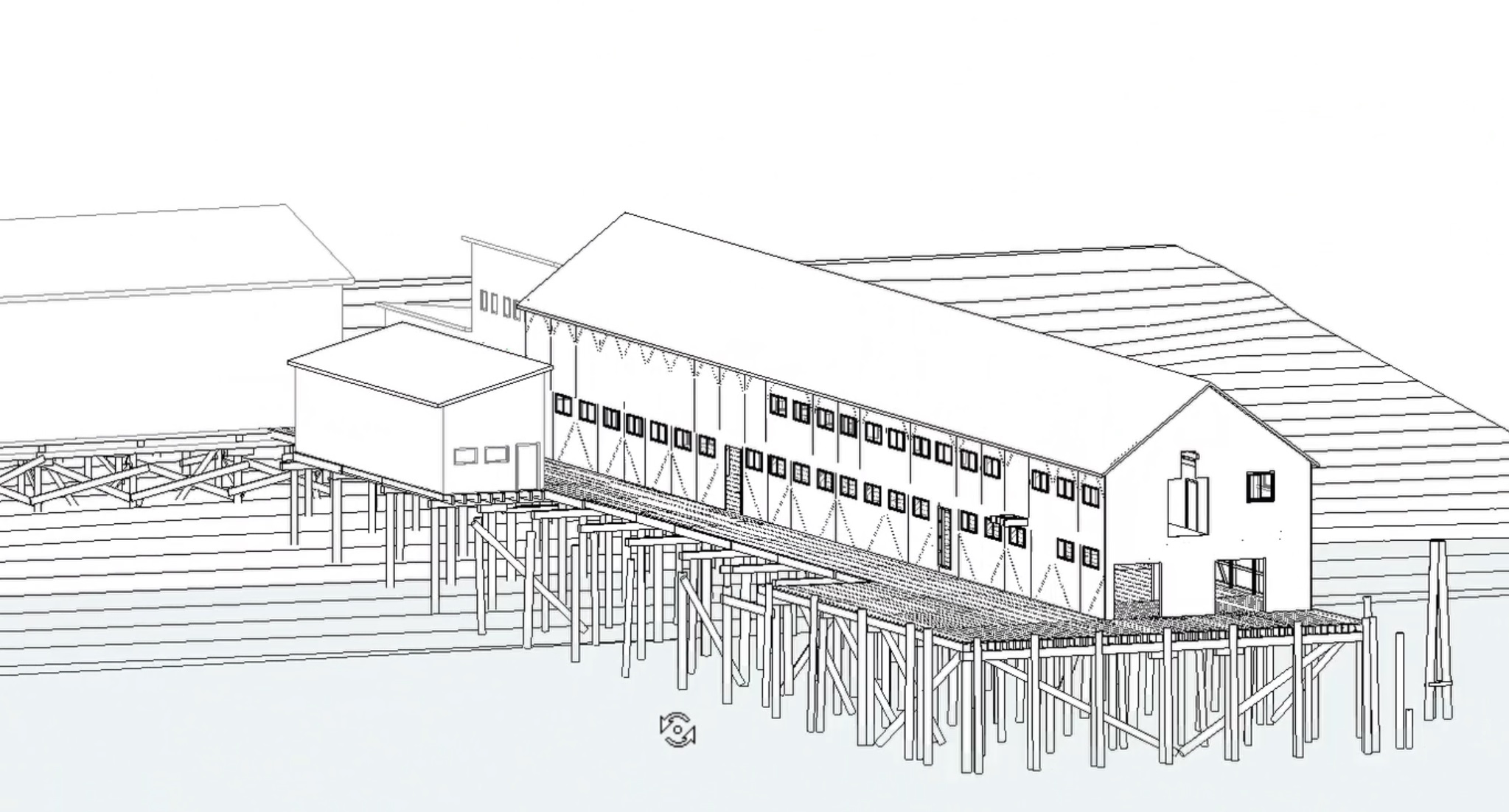
Using the registered point cloud as a base, we develop a detailed 3D model in Autodesk Revit that reflects true as-built conditions across all structural layers.
The model includes structural piles and vertical supports, beams and cross-bracing systems, decking and surface geometry, net house framing and superstructure, and key connections and structural relationships — all modeled from real-world scan data.
Advantages
- check_circle True as-built BIM — not assumptions or estimates
- check_circle Above and below deck structure fully modeled
- check_circle Coordinated Revit model ready for engineering use
Why Use Laser Scanning for Marine Structures?
Compared to traditional methods, laser scanning offers significant advantages for complex, remote, and hard-to-access marine environments.
Complete Capture of Complex Geometry
Piles, bracing, decking, and superstructure documented in full — even irregular and aging structural elements that are difficult to measure manually.
Documentation Below & Above the Structure
Boat-based scanning captures below-deck elements — piles, cross-bracing, and supports — that are completely inaccessible by conventional methods.
Fewer Return Visits to Remote Locations
A single scan campaign captures all data needed for a complete BIM model, reducing costly return trips to fly-in or boat-access sites.
High Accuracy Across Large Structures
Millimeter-level precision across long spans and complex framing — providing a reliable dimensional base for engineering and design work.
3D Revit Model — Remote Pier & Net House, Northern BC
BIM model developed directly from point cloud data, capturing all structural components above and below deck for engineering and planning use.
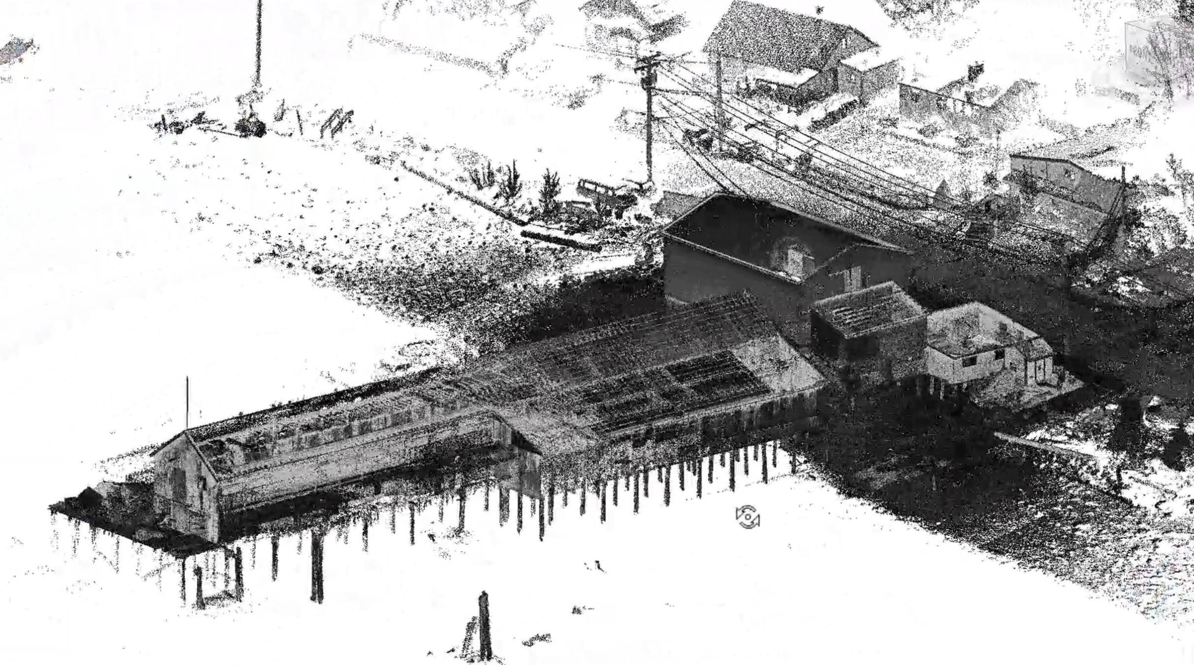
Pier Structure — Point Cloud Model
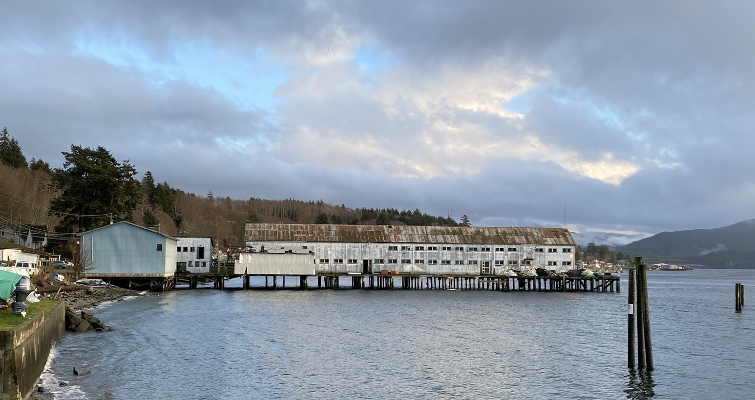
Coastal Pier & Net House — As-Built Structure
Applications for Pier & Marine Structure 3D Models
Our scan-to-BIM deliverables support a wide range of engineering, planning, and asset management workflows for marine infrastructure across British Columbia.
Structural Assessment & Analysis
Accurate as-built geometry for structural engineers to assess condition, capacity, and load-bearing performance of existing marine structures.
Repair & Rehabilitation Planning
Detailed 3D documentation of existing conditions as the basis for repair scope development and rehabilitation design.
Retrofit & Upgrade Design
A reliable BIM base for designing structural retrofits, deck upgrades, and superstructure improvements — without guesswork.
Asset Documentation & Lifecycle Management
A permanent digital record of the structure for long-term asset tracking, maintenance planning, and future project reference.
Engineering & Contractor Coordination
Coordinated Revit models that serve as a shared reference for engineering consultants, contractors, and project managers.
Inspection Support
Precise 3D documentation that supports inspection findings, condition reporting, and structural monitoring programs.
Port & Marina Infrastructure
Complete structural documentation for port facilities, commercial wharfs, and marina infrastructure across BC’s coast.
Remote & Fly-In Location Projects
Efficient single-visit data capture optimized for remote coastal sites where multiple site trips are logistically challenging and costly.
Accurate Marine Structure Documentation Anywhere in BC
If you need accurate documentation of a pier, net house, or marine structure, we deliver a complete laser scan to Revit workflow tailored to challenging environments — including remote and boat-access locations.